FLY MINDEN
The Minden Standard Courses are a set of 17 pre-defined and well described courses for the use of soaring pilots who fly from Minden-Tahoe Airport.
Course distances range from 100 km to 1000 km and meet the FAI prescribed course definitions for triangle, out & return and 3 turn point badge and record attempts.
- Course A - 300km Out & Return
- Course B - 300km FAI Triangle
- Course C - 300km Flat Triangle
- Course D - 300km 3 TP Distance
- Course E - 500km Out & Return
- Course F - 500km FAI Triangle
- Course G - 500km Flat Triangle
- Course H - 500km 3 TP Distance
- Course I - 750km Out & Return
- Course J - 750km FAI Triangle
- Course L - 1000km FAI Triangle
- Course M - 1000km 3 TP Distance
- Course N - 100km FAI Triangle
- Course Q - 500km Out & Return
- Course R - 750km FAI Triangle
- Course S - 1000km FAI Triangle
- Course T - 750km Out & Return
Pacific Soaring Council, Inc. is a non-profit volunteer organization serving glider pilots in Northern California & Nevada.
For only $25 per year you can support your soaring community..
Join Today! Read more...


![]()
We want to hear from you
- Questions or Comments?
- News or Club Event to post?
- ... Let Us Know
Visit our CONTACT US page.
Minden - Standard Course "N"
100 km FAI Triangle
Course Design: Bob Semans
Waypoint / Turnpoint and Task Files
NOTE: All tasks & waypoints are in the SeeYou minden-courses-0916.cup
- Download SeeYou file: minden-courses-0916.cup
- Download SeeYou file without tasks: MindenSC.cup
- Download standard dat file, also works in SeeYou: MindenSC.dat
| Name | Latitude | Longitude | Elevation | |
|---|---|---|---|---|
| Start Pt. | Lake Start, NV | 38º 59.600' N | 119º 41.250' W | 4931' |
| TP 1 | Eagle Peak, NV |
38º 48.000' N | 119º 28.500' W | 8780' |
| TP 2 | Rawe Peak, NV | 39º 11.830' N | 119º 29.370' W | 8130' |
| Finish Pt. | Lake Start, NV | 38º 59.600' N | 119º 41.250' W | 4931' |
| Leg | Km | Smi | Nmi | % | True Course |
|---|---|---|---|---|---|
| 1 | 28.29 | 17.58 | 15.28 | 28.07 | 139° |
| 2 | 44.11 | 27.41 | 23.82 | 43.77 | 358° |
| 3 | 28.38 | 17.64 | 15.32 | 28.16 | 217° |
| Task Dist. | 100.78 | 62.62 | 54.42 |
Task / Course Map from SeeYou
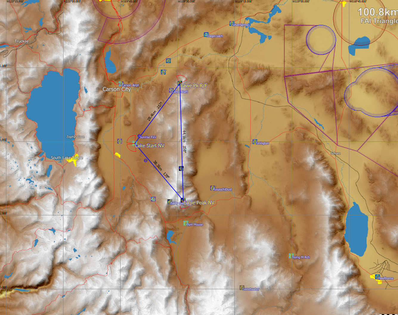
Click Map for larger image
Typical Flight Path:
For speed record attempts, the ideal weather for this course is when a well developed cloud street, with high cloud base, is established over the length of the Pine Nut range. From release, work toward the Pine Nuts until a climb to near cloud base can be achieved. Glide out and make a start at a high altitude and make for the first turn point at the south end of the Pine Nuts. Circle only in the strongest lift, which may not be found until along the second leg. With strong lift along the cloud street on the second leg a single thermal (or less) may be sufficient to complete the course. Be high enough at the second turn point to reach the finish point without turning and to finish not below 1000 meters under the start altitude. Several circuits may be made during a single flight.
With less than ideal weather, this is still a good course to practice flying a declared course and for improving turn point rounding technique. The above course is defined to be flown counter-clockwise. Note that the first and third legs have nearly the same distance. Weather on some days may favor the course being declared for flying in a clockwise direction.
Airports along the course (keep at least one in reach):
Flyin' Mouse, Rosaschi Dusters, Dayton Valley. Minden-Tahoe Airport should normally be reachable from all points on the course.
Some possible weather peculiarities:
When making several starts, be aware that when the west wind picks up at the airport mid afternoon, it signals that cool air from Lake Tahoe is being drawn across the Carson Valley. This often dampens thermal generation in the valley, so pre-start climbs and good climbs on the first leg may then prove difficult.
Traffic cautions:
With a well defined line of clouds over the length of the Pine Nuts, glider traffic will be more concentrated in the narrow strong lift band, so give position reports and watch for high-speed head-on traffic. Also, with high altitude starts over the valley above 9000 feet, expect commercial traffic from the south on a straight in approach to Reno International.
Course Design: Bob Semans