FLY MINDEN
The Minden Standard Courses are a set of 17 pre-defined and well described courses for the use of soaring pilots who fly from Minden-Tahoe Airport.
Course distances range from 100 km to 1000 km and meet the FAI prescribed course definitions for triangle, out & return and 3 turn point badge and record attempts.
- Course A - 300km Out & Return
- Course B - 300km FAI Triangle
- Course C - 300km Flat Triangle
- Course D - 300km 3 TP Distance
- Course E - 500km Out & Return
- Course F - 500km FAI Triangle
- Course G - 500km Flat Triangle
- Course H - 500km 3 TP Distance
- Course I - 750km Out & Return
- Course J - 750km FAI Triangle
- Course L - 1000km FAI Triangle
- Course M - 1000km 3 TP Distance
- Course N - 100km FAI Triangle
- Course Q - 500km Out & Return
- Course R - 750km FAI Triangle
- Course S - 1000km FAI Triangle
- Course T - 750km Out & Return
Pacific Soaring Council, Inc. is a non-profit volunteer organization serving glider pilots in Northern California & Nevada.
For only $25 per year you can support your soaring community..
Join Today! Read more...


![]()
We want to hear from you
- Questions or Comments?
- News or Club Event to post?
- ... Let Us Know
Visit our CONTACT US page.
Minden - Standard Course "H"
500 km 3 Turn Point Distance
Course Design: Bob Semans
Waypoint / Turnpoint and Task Files
NOTE: All tasks & waypoints are in the SeeYou minden-courses-0916.cup
- Download SeeYou file: minden-courses-0916.cup
- Download SeeYou file without tasks: MindenSC.cup
- Download standard dat file, also works in SeeYou: MindenSC.dat
| Name | Latitude | Longitude | Elevation | |
|---|---|---|---|---|
| Start Pt. | Rawe Peak | 39° 11.830' N | 119° 29.370' W | 8130' |
| TP 1 | North Mono Lake (C39) | 38° 06.200' N | 119° 03.230' W | 6785' |
| TP 2 | Dayton Valley (A13) | 39° 14.080' N | 119° 33.750' W | 4412' |
| TP 3 | Conway Ranch Rd. & US 395 Int. | 38° 04.260' N | 119° 10.190' W | 6935' |
| Finish Pt. | Minden Gate | 39° 00.010' N | 119° 45.160' W | 4718' |
| Leg | Km | Smi | Nmi | % | True Course |
|---|---|---|---|---|---|
| 1 | 127.22 | 79.05 | 68.69 | 25.0 | 163° |
| 2 | 133.18 | 82.75 | 71.91 | 26.2 | 340° |
| 3 | 133.63 | 83.03 | 72.15 | 26.3 | 165° |
| 4 | 114.98 | 71.45 | 62.09 | 22.6 | 334° |
| Task Dist. | 509.01 | 316.28 | 274.84 |
Task / Course Map from SeeYou
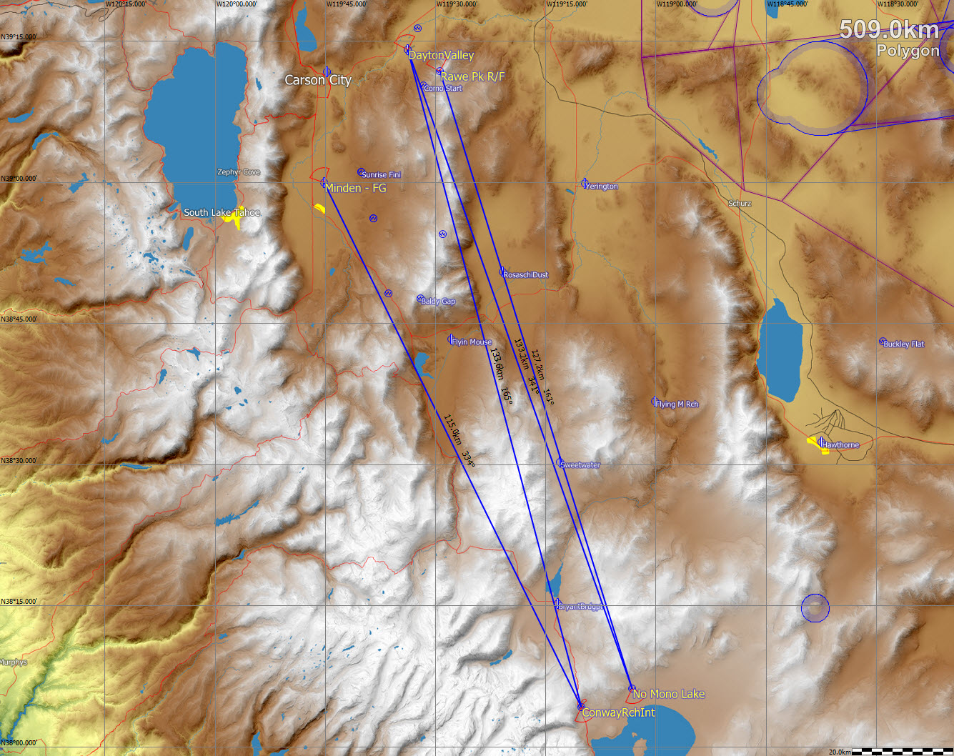
Click Map for larger image
Typical Flight Path:
After the start, run south on the Pine Range. Leaving Bald Mtn. #1 (at the south end of the Pine Nuts) with enough altitude to reach Sweetwater Strip, reach for East Sister Peak at the north end of the Sweetwater range, then south over the range to Mt. Patterson. Jump across Bridgeport Reservoir to the west side of Potato Peak and then south over the high ground to the first turn and back toward Potato Peak.
Near Bridgeport, if enough altitude to reach the west side of Mt. Patterson cannot be gained, deviate to Bald Mtn. #2 at the south end of the Pine Grove Hills. Gain enough altitude to achieve the west side of East Sister Peak or Desert Creek Peak. On either course, work back to Bald Mtn #1 and run the length of the Pine Nut range to Rawe Peak at the north end. Leave Rawe Peak with enough altitude to reach north to the second turn point and back to Rawe Peak. Basically repeat the courses from the first two legs, but flying to the third turn point and breaking off on the forth leg when final glide slope for Minden-Tahoe is achieved. Note: Cloud patterns often dictate significant deviations from this "typical" flight path.
Note: Inclusion of the Finish Point in your Declaration is not required. After the last turn point, all that is required is to land outside a circle with a radius of 105.98 km from the third turn point (plus an allowance to cover any Distance Penalty). For example, the 500 km distance could be achieved by landing at Silver Springs if Minden-Tahoe was under foul weather. (Yerington is not far enough.) However, inclusion of the Finish Point in the Declaration may be advantageous if a high release is anticipated and an approved flight recorder is used. This allows the Finish Altitude to be established by the altitude recorded by the flight recorder at the point and time the declared Finish Point is achieved. If the Finish Altitude is less than 1000 meters lower than the release altitude, a distance penalty will be avoided. A distance penalty might otherwise be incurred if the Finish Altitude is fixed by the elevation of the Landing Point (aka the Finish Point) at Minden-Tahoe Airport.
Airports along the course (keep at least one in reach):
Flyin' Mouse, Sweetwater Strip, Bryant Field (Bridgeport), Lee Vining, Hawthorne, Flying M (Hilton Strip), Sweetwater, Yerington, Rosaschi Dusters, Minden-Tahoe, Dayton Valley.
Some possible weather peculiarities:
Cu-nim blow-off from the Sierra and other high ground; strong southwest wind at lower levels at Wellington and Smith Valley late in the day.
Traffic cautions:
Watch for local glider traffic during the three passes over the Pine Nut range.
Course Design: Bob Semans