FLY MINDEN
The Minden Standard Courses are a set of 17 pre-defined and well described courses for the use of soaring pilots who fly from Minden-Tahoe Airport.
Course distances range from 100 km to 1000 km and meet the FAI prescribed course definitions for triangle, out & return and 3 turn point badge and record attempts.
- Course A - 300km Out & Return
- Course B - 300km FAI Triangle
- Course C - 300km Flat Triangle
- Course D - 300km 3 TP Distance
- Course E - 500km Out & Return
- Course F - 500km FAI Triangle
- Course G - 500km Flat Triangle
- Course H - 500km 3 TP Distance
- Course I - 750km Out & Return
- Course J - 750km FAI Triangle
- Course L - 1000km FAI Triangle
- Course M - 1000km 3 TP Distance
- Course N - 100km FAI Triangle
- Course Q - 500km Out & Return
- Course R - 750km FAI Triangle
- Course S - 1000km FAI Triangle
- Course T - 750km Out & Return
Pacific Soaring Council, Inc. is a non-profit volunteer organization serving glider pilots in Northern California & Nevada.
For only $25 per year you can support your soaring community..
Join Today! Read more...


![]()
We want to hear from you
- Questions or Comments?
- News or Club Event to post?
- ... Let Us Know
Visit our CONTACT US page.
Minden - Standard Course "E"
500 km Out & Return
Course Design: Bob Semans
Waypoint / Turnpoint and Task Files
NOTE: All tasks & waypoints are in the SeeYou minden-courses-0916.cup
- Download SeeYou file: minden-courses-0916.cup
- Download SeeYou file without tasks: MindenSC.cup
- Download standard dat file, also works in SeeYou: MindenSC.dat
| Name | Latitude | Longitude | Elevation | |
|---|---|---|---|---|
| Start Pt. | Sunrise Start Pt. (S05) | 39° 01.120' N | 119° 40.080' W | 5191' |
| TP 1 | Tinemaha Dam - SE end | 37° 03.250' N | 118° 12.670' W | 4100' |
| Finish Pt. | Sunrise Start Pt. (S05) | 39° 01.120' N | 119° 40.080' W | 5191' |
| Leg | Km | Smi | Nmi | % | True Course |
|---|---|---|---|---|---|
| 1 | 252.78 | 157.07 | 136.49 | 50.0 | 150° |
| 2 | 252.78 | 157.07 | 136.49 | 50.0 | 330° |
| Task Dist. | 505.57 | 314.14 | 272.98 |
Task / Course Map from SeeYou
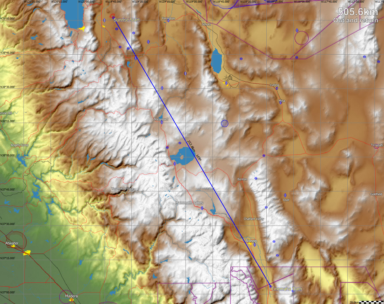
Click Map for larger image
Typical Flight Path:
The usual tactic is to head for Boundary Peak on the north end of the White Mountains, a significant deviation to the east of course line. Leaving Bald Mtn. #1 (at the south end of the Pine Nut range) reach for East Sister Peak at the north end of the Sweetwater range, then to Bald Mtn. #2 (at the south end of the Pine Grove Hills). Then reach for the high ground south of Aurora Mine or the range south of Lucky Boy Pass, then across the flats to the low escarpment at the north end of the Owens Valley and on to Boundary Peak.
On the Whites, fly south, down the range, across Westgard Pass to the high ground at the north end of the Inyo Mountain Range and out to the turn point in the Owens Valley. Reverse course back to the high ground and north to Boundary Peak. Leave Boundary Peak with enough altitude to reach Hawthorne but head a bit more west to the ridge south of Lucky Boy Pass. Work north toward Mt. Grant or until high enough to reach Bald Mtn. #2 or the high ground north along the Pine Grove Hills. Reach to Bald Mtn. #1 and then to Sunrise Finish Point using the Pine Nut ridge to the north only if needed. Note: Cloud patterns often dictate significant deviations from this "typical" flight path.
Airports along the course (keep at least one in reach):
Flyin' Mouse, Sweetwater Strip, Flying M (Hilton Strip), Bryant Field (Bridgeport), Hawthorne, Bishop, Independence. Airports off the course line that may be useful alternates are Circle L, Yerington and Rosaschi Dusters.
Some possible weather peculiarities:
Convergence line around the east side of Mono Lake may be useful on either out or return legs. This convergence often drifts east during the afternoon. The lift band over the Whites may be displaced east or west of the ridge top depending on the shoving match between air masses on the two sides of the range.
Watch for Cu-nim blow-off from the Sierra and other high ground; cool, stable airflow at lower levels south of Walker Lake; strong southwest wind at lower levels at Wellington and Smith Valley late in the day.
Traffic cautions:
High speed, head-on glider traffic in the lift band over the White and Inyo Mtns., any day ... but worst on Saturdays. Before flying in the "White Mountain Corridor," brief yourself on (and print out ) PROCEDURE ALPHA ver C. [ http://pacificsoaring.org/documents/ProcAlphaMap-and-card-Vers-C.pdf ] When not flying over the White or Inyo Mountains, and you hear position reports from pilots flying over these ranges, switch to another frequency or use 123.5 very sparingly!
South end of course transits BISHOP MOA. Be sure to skirt the ammunition disposal Restricted Area R-4811 south of Hawthorne.
Course Design: Bob Semans