NEWS & EVENTS

Get the latest about local events, pilots activities, and soaring news.
- View Our Event Calendar
- Join PASCO's Email News List
- Visit PASCO's Facebook Page
- Join Club News Groups & Forums
See the List of news group in your soaring area.
Pacific Soaring Council, Inc. is a non-profit volunteer organization serving glider pilots in Northern California & Nevada.
For only $25 per year you can support your soaring community..
Join Today! Read more...


![]()
We want to hear from you
- Questions or Comments?
- News or Club Event to post?
- ... Let Us Know
Visit our CONTACT US page.
Andrew Ouellet Captures PASCO Egg
May 1, 2016: Egg is now at Avenal, CA.
Andrew Ouellet captured the PASCO egg today - May 1, 2016 - from Byron with a flight from Avenal to Byron. Not only he made it to Byron, but he also made it back to Avenal in a much more challenging flight dodging large areas of over development, and apparently without some of his instruments after an electric failure. Wow!
Congratulations Andrew on a very impressive flight.
This was exactly 1 year since the last PASCO Egg capture May 1, 2015. So who is next to capture the PASCO egg? ~ Reported by Ramy Yanetz

Here's Andrew's Own Flight Report
May 1, 2016
The most fun part of cross country flying to me is doing something new, whether it's going farther than ever before or flying over places I've never been. Sunday's forecast looked quite good - good enough to 'easily' capture the PASCO egg from Byron and fly over some terrain I'd never flown over in a glider. So, on Friday I coordinated with Ramy Yanetz to make sure I would be able to get a tow out of Byron after landing. Sunday morning I had my liability release paperwork in order and decided I'd fly north and make the call over Panoche. The flight north went without any trouble, reaching over 11k. I thought about detouring around Mt. Diablo but it was already nearly 3pm so I dropped straight in the pattern at Byron.
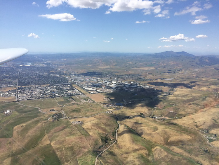
After landing, I looked back over the mountains just south of Livermore and noticed the weak clouds I flew under had vanished and there was a nice blue hole over the San Luis Reservoir due to the marine air pushing through the pass, cutting off the lift in the mountains and moving it east to the valley. Okay I thought, no big deal. Looking south I knew it was going to be a slower flight and decided to fly in the "just see how far you can get" mindset.
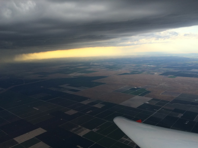
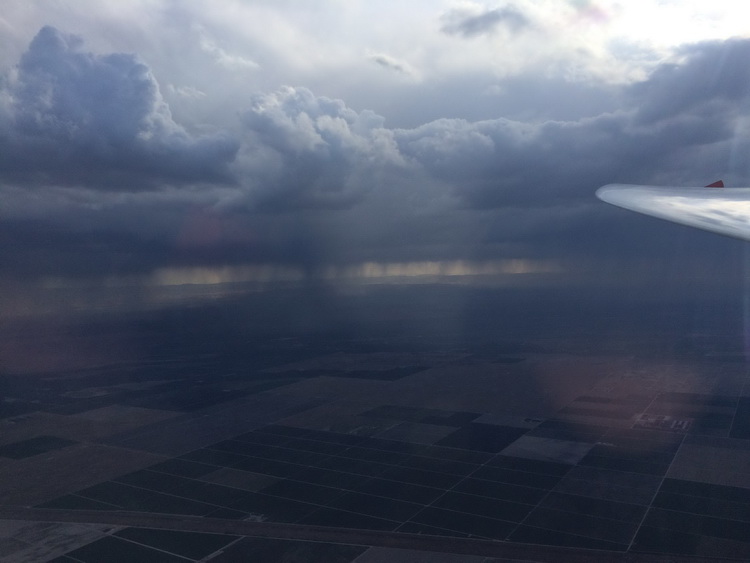
Took around a 3000 foot tow south and let off in decent lift. What looked to be over 100 miles of quite wide over-development was centered over the west side of the valley. I decided I better stay out in the spaced out cumulus forming over the sunny area of the valley, which took me way out East to Modesto. All of a sudden while parked in a thermal only about 25 miles from Tracy my Flarm, power to my Oudie flight computer and my audio vario go dead. I also smell smoke, but not super strong. I flight off the master switch for that battery (thankfully my radio is on a second independent power circuit and battery) and monitor the smoke smell while parked in the thermal. It didn't seem to be getting any worse so I carried on after reaching the height of the worthwhile lift and proceeded paralleling the OD, hopping from thermal to thermal with no high quality GPS source, no audio vario, and about 2.5 hours left on the internal Oudie battery. But the lift was good over the valley, pushing me up over 10.5k! "At least I'll be able to get halfway home" I thought to myself. An hour and a half later, after milking 2kt after 2kt thermal paralleling the OD, which had turned into a major squall line of rain, hail and lightning, it was time to dive under the shelf and through the precipitation towards Harris Ranch. Coming under the shelf, which started about 10 miles east of the line of hail, and about 15 miles west of Fresno I encountered an eerily smooth source of lift under the dark OD. As smooth as wave, it was near hands off circling with me checking the altimeter to make sure the gauges were still alive. With my mechanical vario stuck perfectly at 4kts with not the faintest bump, I took that lift to 8000 and made my dive through the line of hail headed for Harris Ranch.
I was fortunate to have found the nice climb because it was up to 1200 fpm sink as I lost 3300 feet in 5 minutes covering only about 7 miles. My comfortable glide to Harris Ranch soon disappeared. I decided if I could just make it through the sink to Harris, that would be a huge win for the day.
As Morgan and Karl had relayed over the radio, lift was to be found on the West side of the OD. At 3000 feet and about 35 miles out of Avenal my flight computer battery finally died, but I had already gotten my distances and required safe heights plotted out on my SF sectional chart to make HR, New Coalinga and Avenal. I decided to fly direct to New Coalinga and take it from there, but found quite a nice line of weak lift that essentially sustained my altitude past New Coalinga and all the way to Avenal, leaving me ample height to make the prison and return at redline for a celebratory low pass. After 2.5 hours heading north and 3.5 heading south, I was mentally and physically fried but happy. Julie helped me load my wings in the trailer and after chatting a bit, I packed up and headed home.
Quite a fun flight, but I wonder if I could have found that nice smooth 4kts of lift under the wide shelf of OD paralleling the squall line the entire way south. I was afraid if I dove under and found nothing but sink I'd be out of luck so I opted to stay in the sun and chase mediocre looking cumulus grinding it out over the center of the valley. Flying over the valley is quite a bit less stressful than mid-range on the mountains as fields and farm airstrips are plentiful. This fact had me repeatedly switching from towable airports to the most conveniently located fields for easier retrieves the couple times I got low (only once down to 2500 near Tracy and then in huge sink north of Harris Ranch).
Happy Skies!
- Andrew
More flight information and photos at http://www.soaravenal.com/
----
ABOUT CCSC
Central California Soaring Club - www.soaravenal.com - Avenal Airport, Avenal, CA. Central California Soaring Club Membership is open to anyone with an interest in soaring flight. From student pilots to diamond level cross country flying, CCSC membership accommodates everyone. Introductory flights to soaring and the CCSC are available for $99 with one of our certified pilots. You will start with a short briefing on the fundamentals of soaring and a briefing on your flight. Then you will board the glider flown by an experienced pilot. Read more on the Membership Info Page, or email: info@soaravenal.com.